Introduction
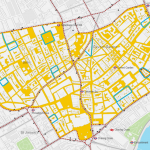
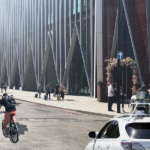
The Inner Ring Road (IRR) is a 12-mile route formed from a number of roads that encircle Central London. The IRR in Victoria has the general effect of concentrating vehicular traffic on certain streets and has the detrimental impact of making certain streets unfriendly to pedestrians and cyclists in terms of the intense vehicle activity and dominance, occasional congestion, and pollution generated.
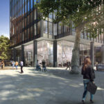
It creates points of severance where the current arrangement and large numbers of vehicles brought to the area limit the cohesion between different streets and spaces hindering walking and cycling. This situation and its associated detrimental impacts introduce significant concerns regarding Victoria’s opportunity to realise its full potential as a place in which to live, work and visit.
As part of a wider initiative seeking to address this challenge, Momentum was commissioned by the Victoria Business Improvement District (VBID) to assess the streets that are part of the IRR in Victoria in terms of their ‘Movement’ and ‘Place’ functions. This followed the 2015 publication of a study undertaken by Publica, ‘Public Realm Vision for Victoria’ which considers how best to improve the public realm of Victoria, and in which the idea to re-route the southbound IRR is mentioned, with associated minor modifications to the northbound route.
Momentum undertook extensive research studying the streets within and surrounding the Victoria IRR to provide a deeper understanding of the streets that would be affected by this idea, and to allow for more informed discussions. It therefore provides the basis for further engagement with stakeholders on how the streets of Victoria are currently being utilised and their physical characteristics, and how this should inform any future changes to the IRR.